

၏ ရွင္းလင္းခ်က္ My GPS Altitude and Elevation
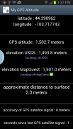
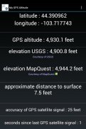
Displays:
1) latitude and longitude
2) altitude according to your device's satellite GPS reciever
3) elevation according to MapQuest™ and USGS
4) subtracts elevation from altitude for an <b>approximate</b> distance to surface
Optionally email or text message location information to yourself or a friend.
This description is machine translated. <a href="https://play.google.com/store/apps/details?id=com.gpstools.gpsaltitude&hl=en">Click to read the original english description. </a>
<b>simple explanation of displays from top to bottom: </b>
1) latitude and longitude in decimal format according to your GPS receiver.
2) altitude according to your GPS receiver adjusted for sea level. (Note that this is not so accurate due to the inherent inaccuracy of low cost GPS receivers. +-15 meters is not uncommon)
3 a) surface level elevation provided by USGS (North America only)
3 b) surface level elevation provided by MapQuest
4) approximate distance to surface
5) accuracy of GPS satellite signal
6) seconds since last GPS satellite signal
<b>detailed explanation of displays from top to bottom: </b>
1) latitude and longitude in decimal format according to your satellite or network GPS receiver. Network GPS is used if satellite is not available. In this case, this text will be orange in color and (2) will not be available.
2) altitude according to your satellite GPS receiver adjusted for sea level. (Note that this is not so accurate due to the inherent inaccuracy of low cost GPS receivers. +-15 meters is not uncommon)
3 a) surface level elevation provided by USGS (this requires a data connection to work and is limited to North America * *)
3 b) surface level elevation provided by MapQuest (this requires a data connection to work and is not available in extreme latitudes *)
4) approximate distance to surface. This simply subtracts (3) from (2). If you are in USGS coverage area, USGS and MapQuest data is averaged.
5) accuracy of most recent GPS satellite signal
<b> * * * Requires a <b>satellite</b> GPS reciever to function properly. Wifi assisted GPS does not report altitude. ***</b>
<b> * * * Note that GPS does not work well indoors * * * </b>
<b> * * * Note that GPS accuracy depends on the receiver in your device * * * </b>
<b> * * * Note that a data connection is required to get elevation data from Mapquest or USGS * * * </b>
units include:
meters
feet
yards
For use of topographic data, special thanks to:
USGS (United States Geological Survey)
Mapquest
Frequently asked questions:
Why not include this in your existing ' GPS Coordinates ' application?
Several reasons:
1. Most people do not care about altitude, and it would clutter the simple interface.
2. The geopotential model for the earth is large, and would easily double the size of the app.
3. Frequent network calls to fetch elevation data is probably not desired by most people.
4. The ' GPS Coordinates ' application uses assisted GPS (WIFI), but that does not have an altitude component.
* MapQuest coverage includes latitude 60 to latitude-54. Note that most of Norway is not covered.
* * USGS coverage includes all United States territories, Southern Canada, and most of Mexico and the Caribbean.
Special note to consider: Much of the raw data used by elevation providers comes from orbital radar map missions, namely the ' Shuttle Radar Topography Mission ' conducted in 2000 by STS-99. Note that mountains and canyons (or any step surface) do not reflect radar in an optimal manner.</br></br></br></br></br></br></br></br></br></br></br></br></br></br></br></br></br></br></br></br></br></br></br></br></br></br></br></br></br></br></br></br></br></br></br></br></br></br></br></br></br></br></br></br></br></br></br></br></br></br></br></br></br></br></br>
My GPS Altitude and Elevation - ဗားရွင္း 1.4
(18-06-2016)My GPS Altitude and Elevation - APK သတင္းအခ်က္အလက္
APK ဗားရွင္း: 1.4package: com.gpstools.gpsaltitude


